Reconstructing Ancestral Architecture in Virtual Reality
Dennis R. Holloway
Papers of the Archaeological Society of New Mexico, Vol. 46, 2020
When we build ... let it not be for present delights nor for present use alone. Let it be such work as our descendants will thank us for, and let us think ... that a time is to come when these stones will be held sacred because our hands have touched them, and that men will say as they look upon the labor, and the wrought substance of them, See! This our fathers did for us! (Ruskin 1849:177)
In today's world we sometimes forget that each of us has descended from an unbroken lineage beginning with Earth's first life forms 3.8 billion years ago. More recently, every person alive has descended directly from a (pre-Homo sapiens) common individual ancestor, Y-chromosomal Adam, who lived in Africa around 338,000 B.C. We are each genetic cousins of every other living human being. From the beginning of life's evolution, species have been creating shelter to adapt to the conditions of their ambient environments. Architecture was produced by our ancestors from as far back as the beginning of the single-cell animals, and other living creatures fashion architectural constructs. Amoebas make tests, mollusks make shells, spiders weave webs, bees form comb, beavers build lodges and dams, and birds and apes construct nests. Human ideas about making architecture and the materials used have evolved directly from this ancestral architecture. As Homo sapiens migrated out of Africa, we encountered diverse environments extremely different from our original savannas and adapted to them. Our physiology, social organization and architecture changed through these adaptations. The architecture provided safety, thermal comfort, repose, and a place to withdraw from the conditions of physical environment. Analysis of polar ice cores reveal that the greenhouse gases in Earth's finite atmosphere have increased and decreased in a constant pattern that maintained a relatively stable planetary temperature for hundreds of millennia, with some disruption to that pattern from volcanism and collisions with objects from space. In the billions of years that architecture evolved right up until the First Industrial Revolution of Homo sapiens, architecture did not have any appreciable effect upon the natural balance of the ecosystem or planetary temperatures, a quality we now call "sustainability." At the beginning of the nineteenth century, the exploitation of coal as a cheap energy source resulted in a radical upswing in the greenhouse gases expelled into the atmosphere, as evidenced by early reports of extreme air pollution in urban England. The dramatic increase in human-made greenhouse gas emissions traps more and more solar energy converted to heat in Earth's fi nite atmosphere and ocean. The temperature rise is disrupting weather cycles, resulting in dangerous regional climate changes. Frozen methane in permafrost and the oceanic floor thaws to greenhouse gas and is released into the atmosphere, dramatically increasing global temperatures in a feedback loop. The rising temperature is causing catastrophic melting of the glaciers and polar ice, and this will result in sea level rise that will inundate the world's coastal populations and cause immense chaos in the near future. Contemporary human architecture and built environment is the source of around 60 percent of greenhouse gas emissions. The limestone cement industry alone contributes 20 percent of these. Clearly the pedigreed architecture of contemporary Homo sapiens is problematic and ill-conceived. What are architects to do? In searching for a sustainable built environment paradigm, architects should study the architecture of our ancestors to better understand how they avoided overheating the world. How did the ancestors conceive, construct and use their architecture? This may sound like the question of a romantic or a primitivist, but this knowledge may be essential to stave off impending life extinction. The sciences of anthropology and archaeology will play a crucial role in this investigation, which may turn out to be their most important raison d'etre. Archaeologists can raise the public's visual imagination and awareness of the sustainability of human built environment of the past. To accomplish this, interdisciplinary collaboration with architects will be necessary. How did human architecture of the past, for such an expanse of time, avoid exploitation and combustion of fossil fuels? When I moved my architecture practice to Taos, New Mexico in 1990, I lived for the first time where architecture of the ancient indigenous people of the Americas was present in my immediate neighborhood. My first visits to the pueblos of Taos and Acoma and, later, the Ancestral Pueblo architecture of Chaco Canyon and Mesa Verde profoundly changed the way I perceived architecture. I learned that architecture was more than the expression of modern high technology for technology's sake, a philosophy my modernist professors had advanced. Simpler materials and methods could accomplish the requirements of a climate-responsive delightful architecture. Beginning in the mid-1970s I had been fortunate to have as my clients people who wanted to build sustainably, utilizing the sun for heating, ventilating, and electricity. In the American Southwest, adobe, mud, stone and non-industrialized wood construction was well established in pre-Columbian times. These materials were a good fit with the high thermal mass passive solar architecture prototype, which I had been developing. The substance of Ancestral Puebloan architecture was truly sustainable. It was the prototype of living in balance with the natural world, about which I had not been taught in my university professional education. My life in the Southwest profoundly expanded my education as an architect. During this time, I was beginning to use cutting edge computer graphic technology in my practice. A client, Taos artist, Ronald Davis, introduced me to Cinema 4d™ software, which made it possible to construct photorealistic three-dimensional graphic computer virtual reality (VR) models of architecture. Soon I was not only presenting my design work for clients in VR but, as a 'hobby', also making VR models of Ancestral Pueblo places, using measured drawings from archaeological surveys. Paul Williams, archaeologist with the Bureau of Land Management's Taos Field Office, gave me my first commission to model VR reconstructions of the ancestral Tewa pueblos of Hupobi and Howiri near Ojo Caliente, New Mexico. Paul agreed with me that archaeological survey reports were missing visually potent graphic reconstruction of sites; VR was just the ticket. My VR exploration of the architecture of ancestors has become an obsession since then. When I had completed about 100 VR models of the Ancestral Puebloans' and Mound Builders' architecture, a visit to the ruins of Monte Alban in Oaxaca, Mexico opened my mind to VR investigations into the Zapotec, Maya, Aztec, Intermediate Zone, pre-Inca and Inca architectures. Even though the distance between the sites of these diverse cultures was great, I found that the "look" of the Cinema 4D™ VR models unifi ed these places as a visual continuum. Th ese were, after all, places built by genetic "cousins." In 2013 I was invited to teach architecture in Vietnam. I focused my lectures on urban and rural relocation planning to prepare for the impending sea-flooding of Vietnam's 50-million-person coastal population. The students and faculty responded enthusiastically to this critical problem I issued in their design studios. One weekend, faculty of Duy Tan University in Danang graciously invited me to visit the ruins of the My Son Sanctuary near Hoi An. There, Hindu/Buddhist Champa Culture had built amazing brick Shiva temples from the fourth to fourteenth centuries A.D. These temples are esoteric to the world and also to the current Vietnam culture, which has been amnesic about the northern Viets' forced relocation of the Champa and their architecture into Indonesia. Forgotten My Son had been engulfed by the jungle, until rediscovered by the French in 1898. So impressed was I with the ruins of My Son that I decided to model VR reconstructions of the temples on my laptop, working into the hot humid summer nights of Danang. The resulting VR reconstructions have now been published in Vietnam. The portfolio of VR architecture reconstructions included in this paper are a small sampling of my VR archive, which currently contains 400+ sites from six continents. Th e archive is being prepared for publication, which will probably be online and paperless. More selections from the archive can currently be viewed at https://www.dennisrhollowayarchitect.com/VirtualRealityArchaeologyGlobal.html. Each model has been rendered from multiple view angles. C4d™ software can also animate the models in red/green stereo; that is for another lifetime or for someone else to accomplish. The archive documents this architect's journey of discovery of ancestral places around the globe, many of which I may never visit physically, but which have been made possible through the dedicated work of the archaeologists with transits and trowels. Our ancestors have spoken to me through their remembered architecture. They did this for all of us. Today is tomorrow; the future lies in the past.
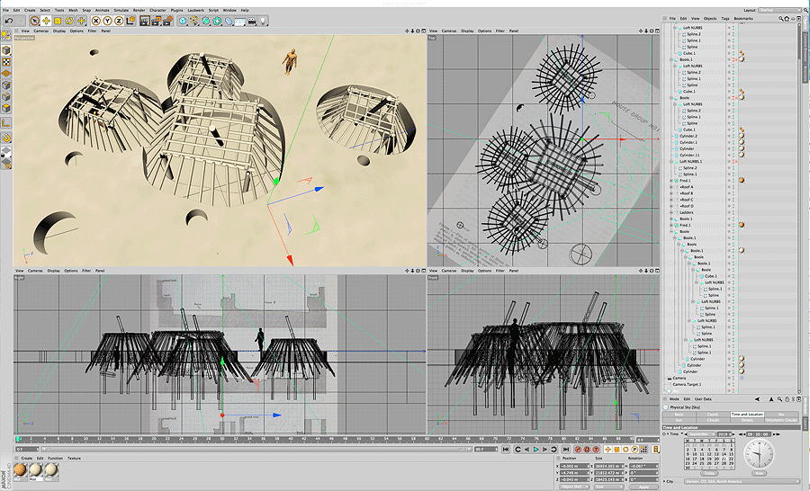
Figure 1. Screen capture of Cinema 4D™ software's (www.maxon.net/en-us/) graphical user interface showing VR modeling of Kiatuthlanna pit houses. The windows show global site location, perspective view, three orthographic views, a list of 3-D objects, physical sky, solar time and geometry, date, object surface shaders and textures used, camera lens type, camera fi eld of view, and animation setup.
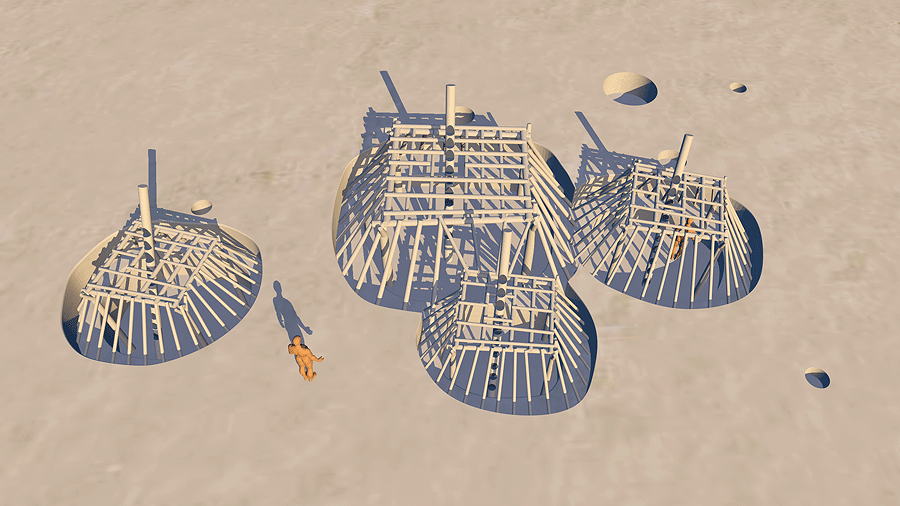
Figure 2. Kiatuthlanna Pithouses. Th is ancestral Zuni site is in New Mexico and dates to the Basketmaker III Phase, 450 to 750 A.D. (Roberts 1932). Th e VR model of the house pits reveals sunken wooden structural frames (earthen roofs removed), rooftop entrance pole ladders, adjacent caches, and human scale.
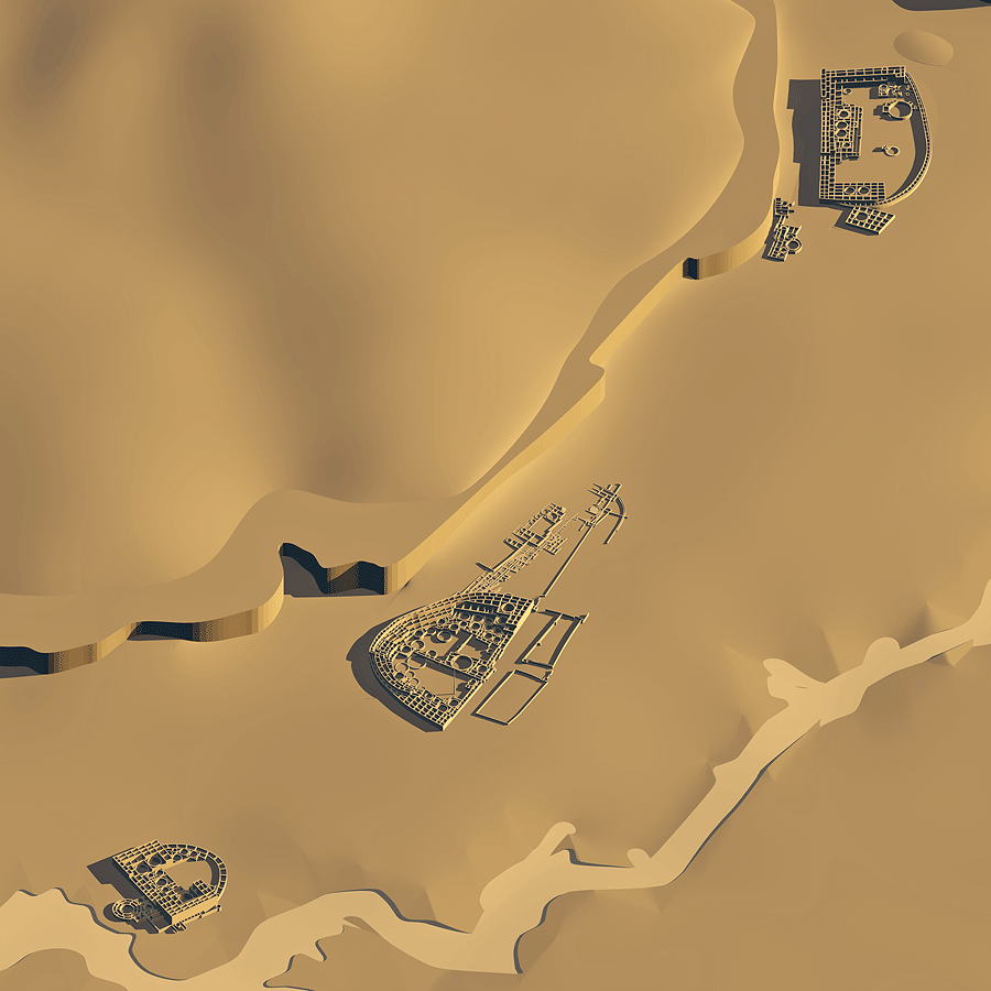
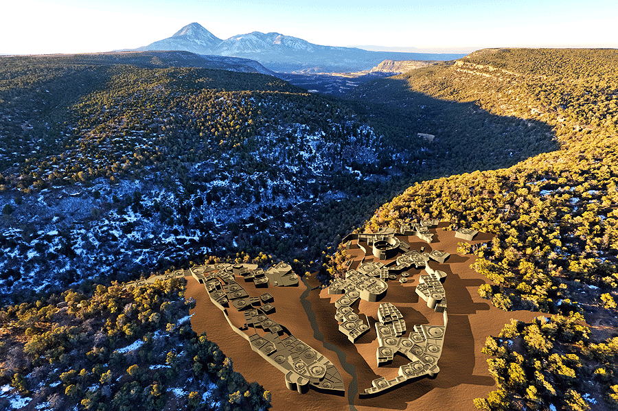
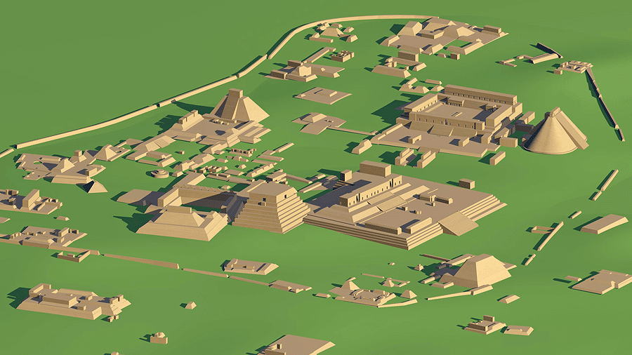
Figure 3. Ancestral Puebloan Chaco Canyon "Downtown" Great Houses, New Mexico, c.1200 A.D. From lower left to upper right: Pueblo del Arroyo, Pueblo Bonito (including Hillside Ruin), and Chetro Ketl (including Talus Unit). Th e view utilizes a 12° field of view software camera for long distance high resolution. In this VR model each Great House was constructed separately from measured archaeological survey drawings and then copied and pasted into the schematic scaled topographic model of the Chaco Wash. (Lekson 1984).
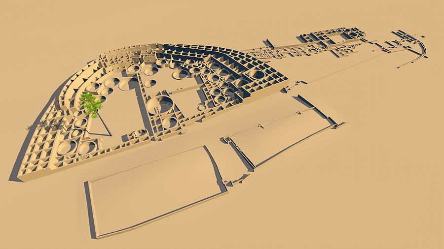
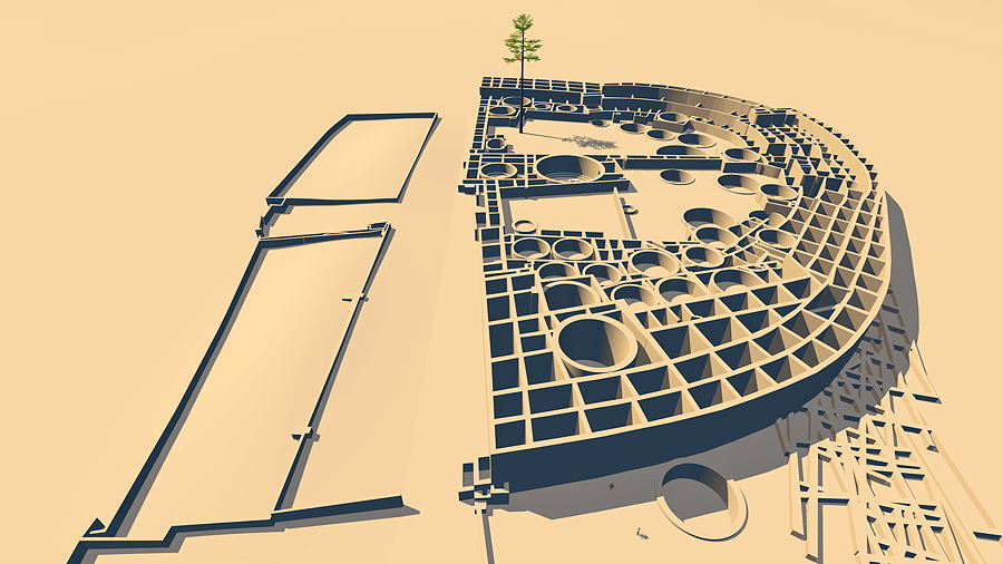
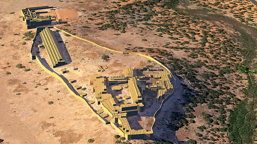
Figure 4. Pueblo Bonito, a Great House in Chaco Canyon, New Mexico, c. 1085 A.D. View of the VR model with roofs removed, looking north, including details of Hillside Ruin, eastern foundations of unbuilt walls, south masonry-faced mounds, and west plaza lone pine tree (Lekson 1984).
Figure 5. Pueblo Bonito, a Great House in Chaco Canyon, New Mexico, c. 1085 A.D. View of the VR model looking east with roofs removed, including details of unbuilt eastern foundations, masonry-faced south mounds, and west plaza lone pine tree (Lekson 1984). VR archeological reconstructions can be viewed from an infinite number of positions and can also be animated in red/green stereo.
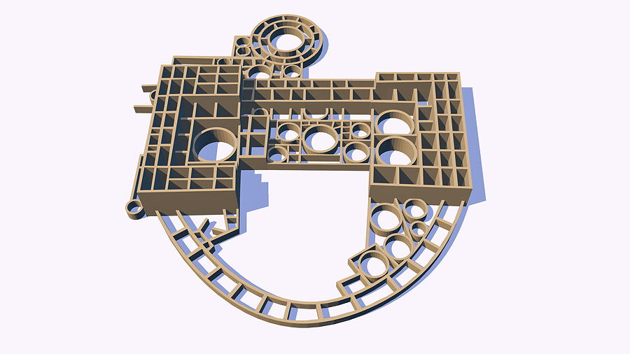
Figure 6. Pueblo del Arroyo, a Great House in Chaco Canyon, New Mexico, c.1110+ A.D. (Lekson 1984). View of the VR model with roofs removed, looking northwest, set upon plain white ground to emphasize the complexity and elegance of the design layout.
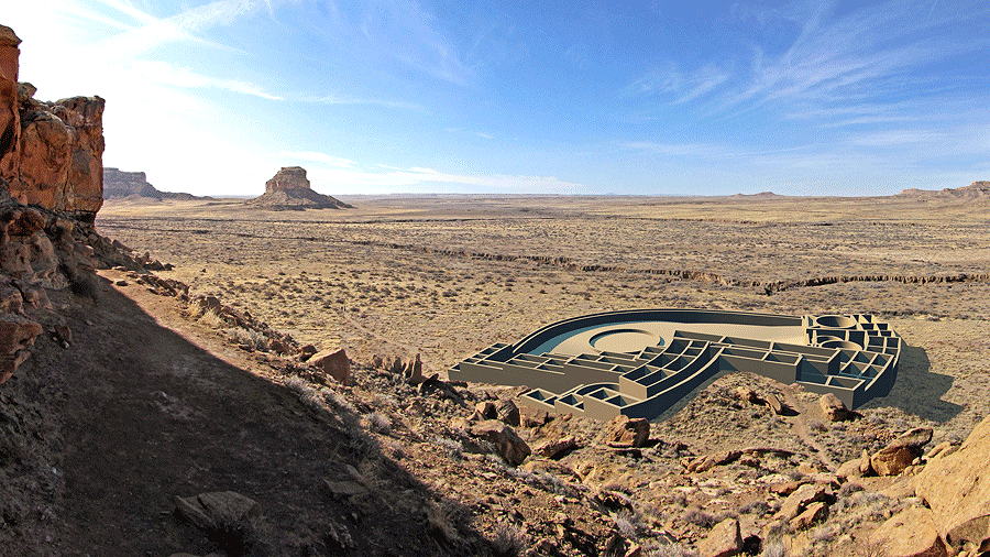
Figure 7. Una Vida, a Great House in Chaco Canyon, New Mexico, constructed c. 850 to 1100 A.D. (Lekson 1984). View of the VR model and the Great House milieu; view south with Fajada Butte in the distant left; the scene is a photomontage of the 3-D model, shown roofless to reveal room structure, angled and shadows cast authentically, and pasted into author's site photograph.
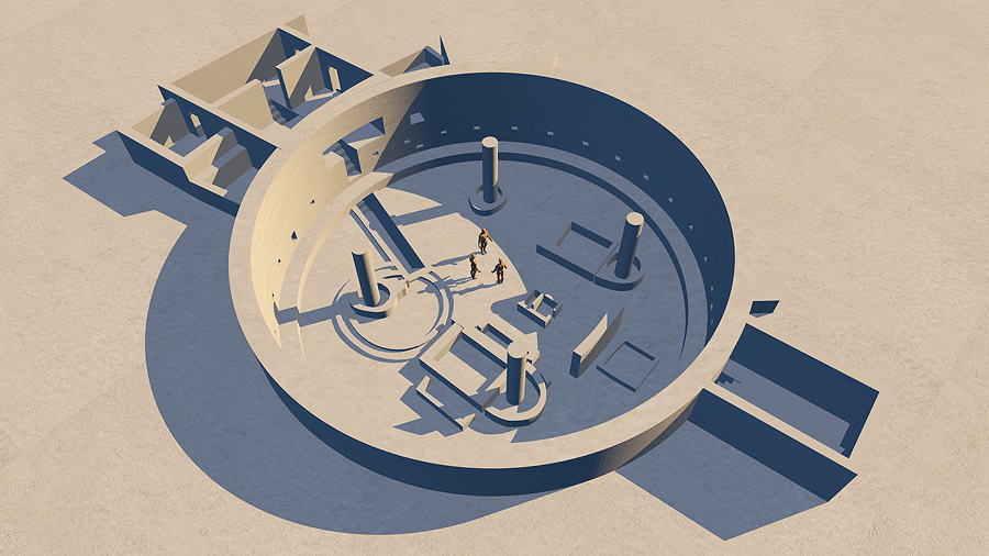
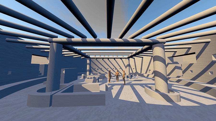
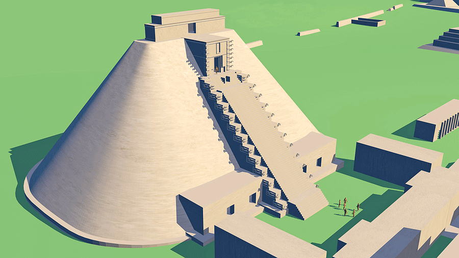
Figure 8. Casa Rinconada, a Great Kiva in Chaco Canyon, New Mexico, c.1050+ A.D. (Aveni 1982). View of the VR model looking northeast, shown without roof structure.
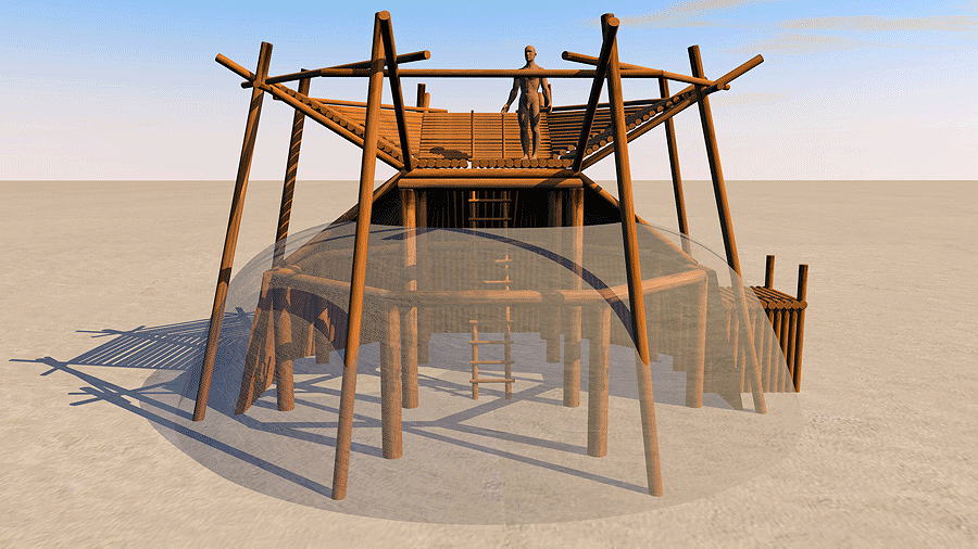
Figure 9. Casa Rinconada, a Great Kiva in Chaco Canyon, New Mexico, c.1050+ A.D. (Aveni 1982). View of the VR model interior, looking southwest, showing human scale and hypothetical roof structure of tree logs. These were brought from mountains 60-70 miles distant without draft animals or wheels.
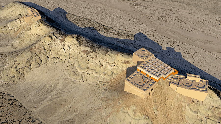
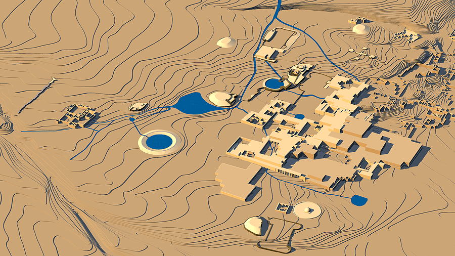
Figure 10. Bis Sa'Ani, a pinnacle outlier complex of Chaco Canyon, New Mexico, c.1100 AD-1150 A.D. (Marshall 1982). View of the VR model looking northwest. The 3-D site architecture has been constructed onto a 3-D topographic computer model upon which a scaled satellite photograph of the actual site has been electronically "mapped".
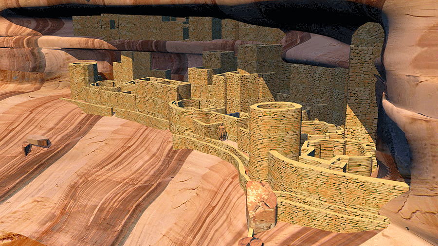
Figure 11. The cliff dwelling of Mug House, Mesa Verde National Park, Colorado, occupied from 1100 to 1300 A.D. (Rohn 1971). Th e 3-D architecture was constructed into the 3-D model of the alcove; the entire scene was modeled from sourced measured archaeological 2-D drawings. Masonry and cave surfaces have been electronically texture-mapped for effect. Sun angle time has been precisely set in the C4d™ software at August 10, 2005, 3:10 PM MST.
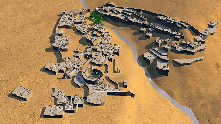
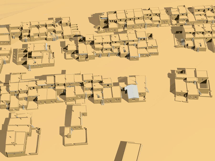
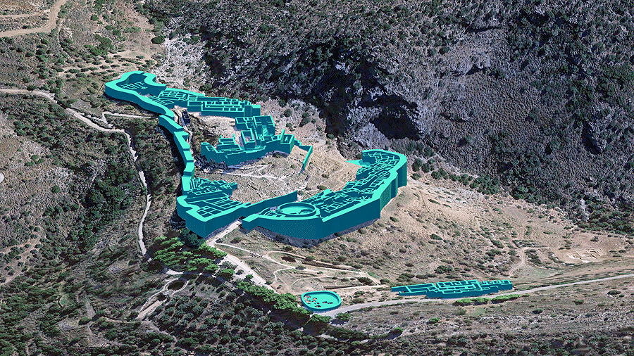
Figures 12 and 13. Sand Canyon Pueblo, near Cortez, Colorado, occupied from 1000 to 1300 A.D. (post-Mesa Verde) (Kuckelman 2007). Top: view of the VR architecture and topography model, showing roofs and ladders of rooms and kivas. Bottom: 3-D Pueblo model photomontage into actual Sand Canyon aerial photograph by photographer Adriel Heisey in collaboration with Crow Canyon Archaeological Center, Cortez, Colorado. Sleeping Ute Mountain is seen in the distance.
Figure 14. Pecos Pueblo (Cicuye), New Mexico, occupied from 1325 to 1838 A.D. (Kidder 1958). View of the VR 3-D model of the pueblo and Catholic mission church and convento; the model is constructed upon the 3-D site topographic model upon which a scaled satellite photo of the site has been surface-mapped.
Figure 15. Paquimé (Casas Grandes), Chihuahua, Mexico, occupied 1130 to 1450 A.D. Partial view of the model constructed with information from Charles Di Peso's measured drawings (Di Peso 1974). Shown is the sophisticated hydrological engineering of this major Southwest trading center.
Figure 16. Acoma Pueblo, New Mexico. Th e VR computer model was constructed with information from the architect-measured drawings of the 1934 Historic American Buildings Survey Project (HABS) (Nabokov 1986). Shown is the single metal roof in the entire stone, mud, fiber, and wood construction of the "Sky City" at that time.
Figure 17. Earth house, Koryak Culture, Kamchatka Krai, eastern Russia (Jochelson 2016 [1908]). View of the VR 3-D model with the earth cover made translucent to reveal interior four-post-in-octagon structure and roof top social gathering "basket" accessed by a ladder through the smoke hole.
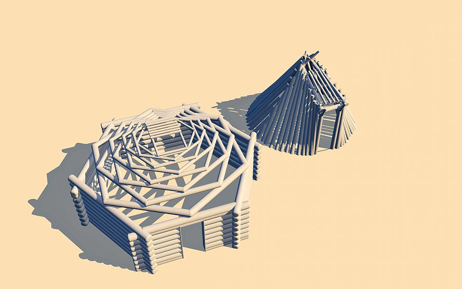
Figure 18. Diné (Navajo) hogan, still in use, southwestern United States (Jett and Spencer 1981). The VR models of the elegant structures of female "cribbed" log dome hogan (left) and conical male hogan (right).
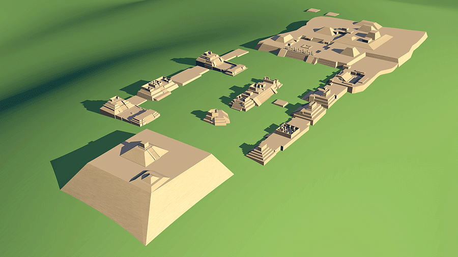
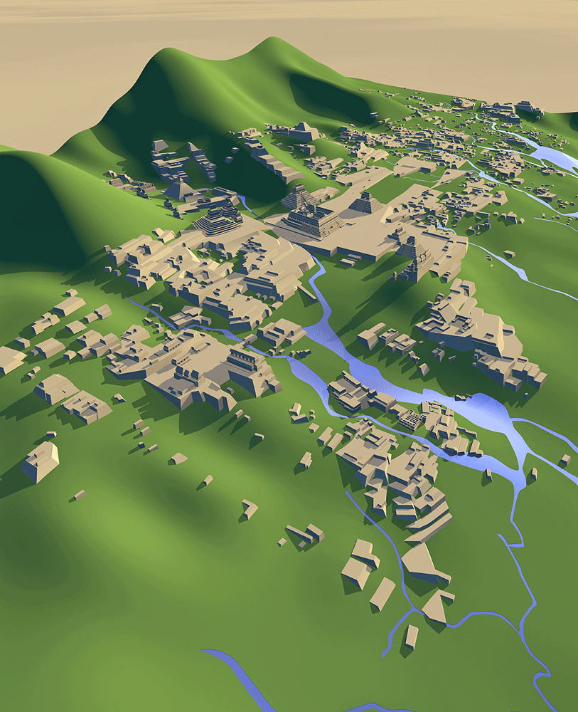
Figure 19. Cahokia, located on the Mississippi River near St. Louis, Missouri, inhabited from 700 to 1400 A.D. (Morgan 1980). The central Monks Mound (beginning 900-955 A.D.) is the largest Pre-Columbian earthwork in the Americas and the largest pyramid north of Mesoamerica. A "parallel" view software camera is used to capture all the mounds and plazas of the central complex at equal scale.
Figure 20. Monte Alban, Oaxaca, Mexico, a ceremonial center from 500 B.C. to 750 A.D. (Markus & Flannery, 1996). Corn was first hybridized in this culture's region. An astronomical observatory is the left-most building at the center of the main plaza.
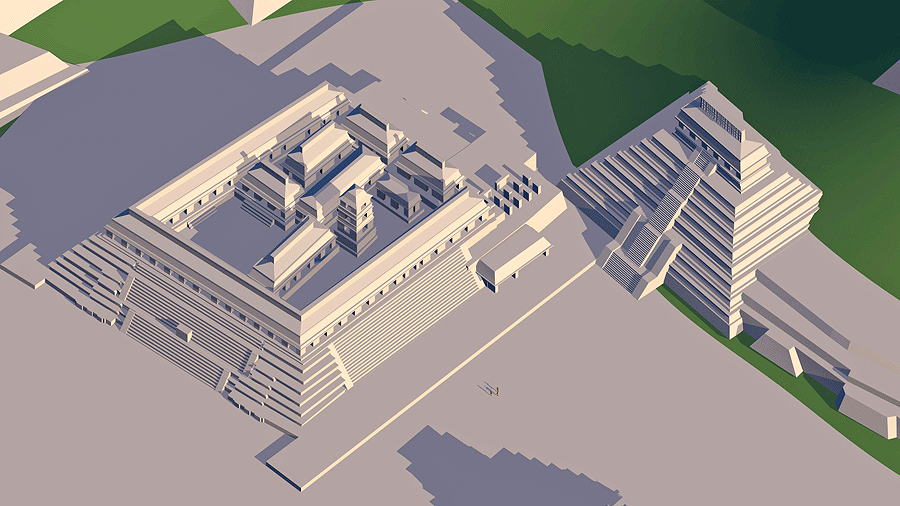
Figure 21. Uxmal, Puuc Region, Yucatan, Mexico, occupied 500 to 950 A.D. (Andrews 1975). The monumental scale of masonry and intricate complexity of the Mayan city cannot fail to impress.
Figure 22. Pyramid of the Magician, Uxmal, Puuc Region, Yucatan, Mexico, occupied 500 to 950 A.D. (Andrews 1975). The view of the VR model shows the entrances to three levels of the Mayan cosmos.
Figure 23. The Mayan site of Palenque (anciently known as Lakamha: "Big Water"), located near the Rio Usumacita in Chiapas, Mexico, occupied from the Early to Late Classic c. 226 B.C. to 799 A.D. (Barnhart 2001). View of the VR model constructed from sourced architectural, topographic, and surface water information. Research and construction for this VR model was a profound revelatory experience for the author.
Figure 24. Royal Palace and Pyramid of Inscriptions, Palenque, located on the Rio Usumacita in Chiapas, Mexico, occupied from 226 B.C. until 799 A.D. (Barnhart 2001). The palace contains a unique four-story tower. The 21-m (68-ft) Pyramid contains the Royal Tomb of Pakal the Great (603 to 683 A.D.).
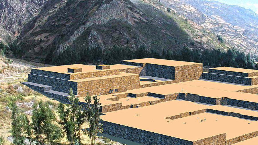
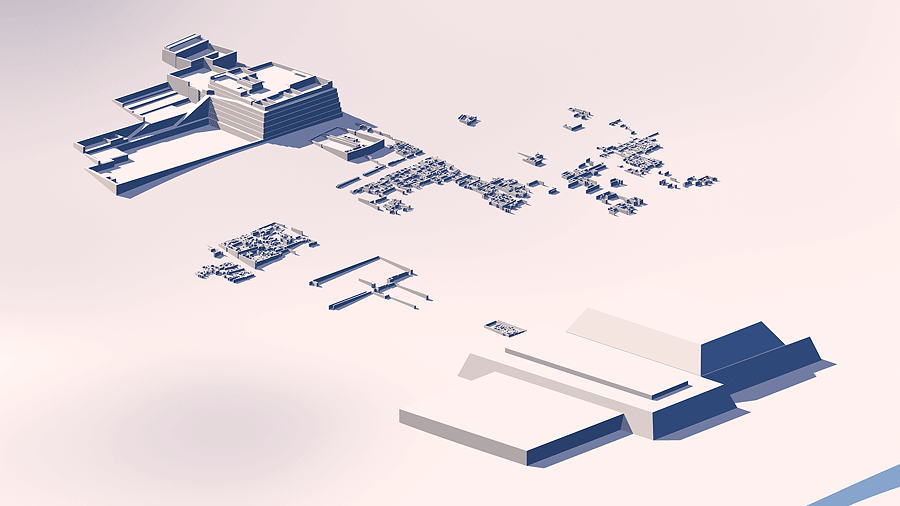
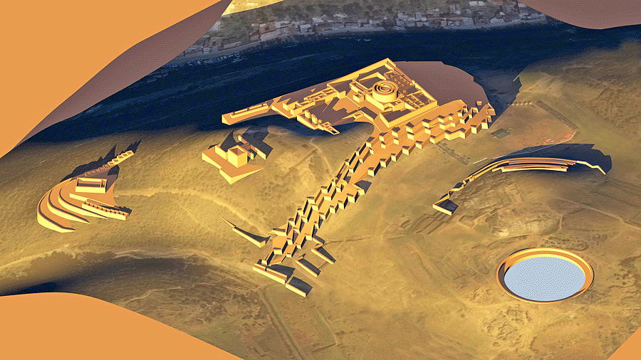
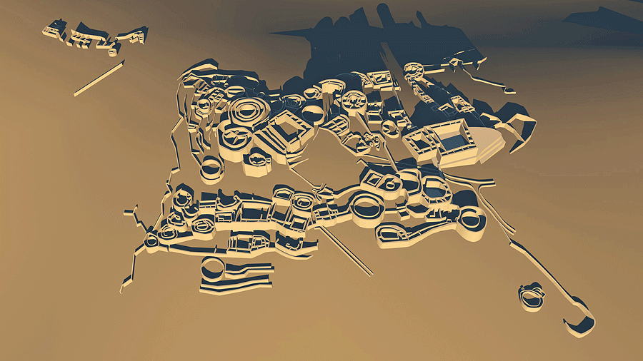
Figure 25. Chavín de Huántar, Ancash region of Peru, occupied from 1200 to 500 B.C. (Conklin and Quilter 2008). VR model of the architecture photomontage scaled overlay on actual site photograph. The upper truncated pre-Inca Chavín pyramids contain a labyrinth of tunnels and are the sanctum of the arcane Lanzón stella.
Figure 26. Huacas de Moche, consisting of the Huaca del Sol and Huaca de la Luna (Pyramids of the Sun, right, and Moon, left), which are the mud-brick remains of Cerro Blanco, a pre-Inca Moche capital city occupied between 100 and 800 A.D., located near Pacific coastal city of Trujillo, Peru (Castillo 2010). Remnants of the residential area ruins lie between the pyramids.
Figure 27. Sacsaywayman, located high above the city of Cusco, Peru widely considered to be from an unknown pre-Inca civilization, c. 1275-1425 A.D. (?) (Hemming and Ranney 1982). The zig-zag walls of gigantic megalithic fitted stones are undated. VR model of architecture and satellite photo mapped onto topographic model.
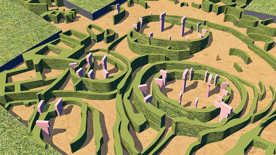
Figure 28. Yayno, 400 to 800 A.D., located in Ancash, Peru (Lau 2010). Th e pre-Inca Recuay city is built at an elevation of 4,000 m (13,123 ft). The VR architecture and topography model illustrates the extraordinary stone city walls of concentric circles and squares.
Figure 29. Göbekli Tepe in the Anatolia region of Turkey, dating to the tenth to eighth millennia B.C. (Schmidt 2010). View of the VR model of the partially excavated site, which was mysteriously, intentionally, buried. Many T-shape sculpted megalithic stones have been found here.
Figure 30. Mycenae, south of Athens, Greece; acropolis site occupied continuously c.10,000 B.C. until decline around 1200 B.C. (Angelopoulos 2015). The VR 3-D site architecture has been constructed onto a 3-D topographic model upon, which a scaled satellite photograph of the actual site has been electronically mapped.
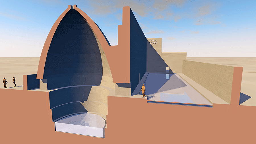
Figure 31. A Persian yakhchal (ice pit), invented prior to 400 B.C. (Mehdipour and Namazian 2012). View of the VR section model; the shadow of the east-west wall kept the water in the northern shallow pond cool enough to freeze during winter nights. Ice blocks were then cut and stored under the earthen dome for summer use.
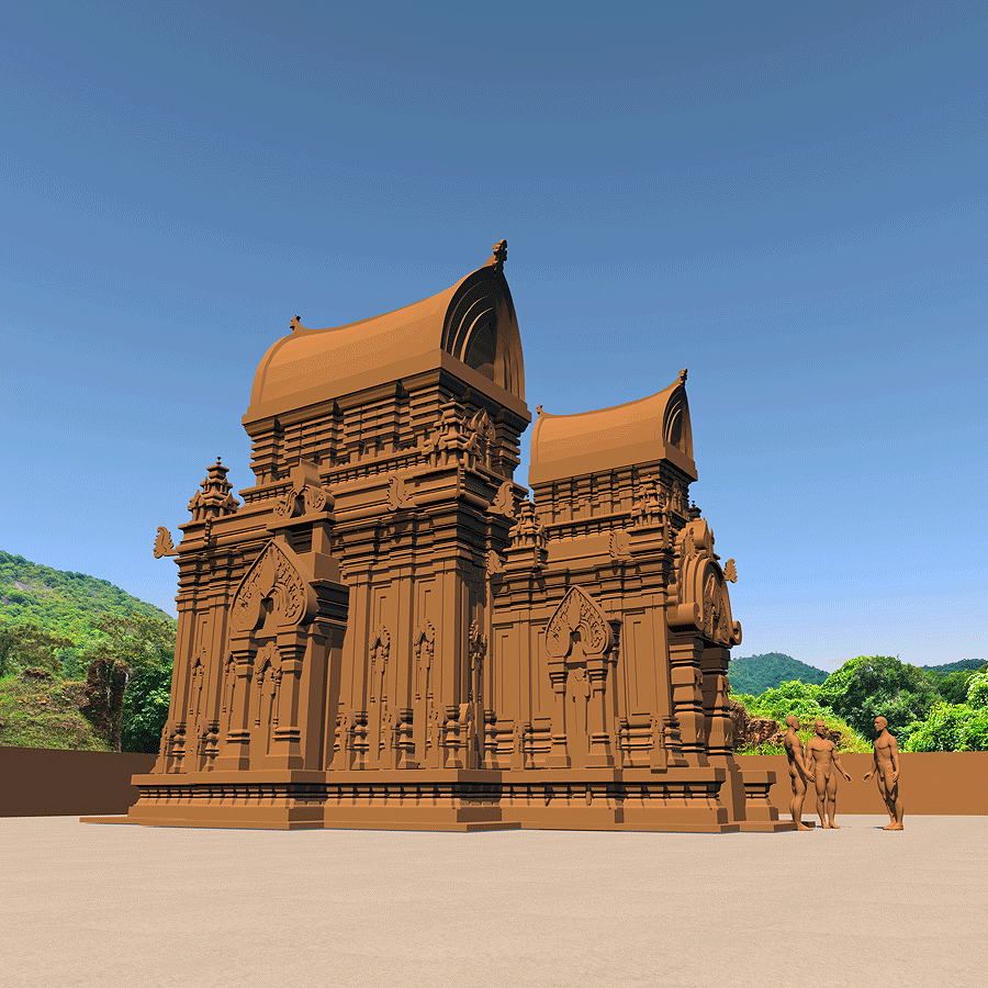
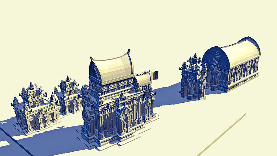
Figure 32. My Son Sanctuary, Shiva Temple C1, Vietnam; the former capital of the Champa Kingdom, c. fourth to the fourteenth centuries A.D., focus of the Cham royals' Hinduism (Thanh 2015). In 1904 archaeologist Henri Parmentier, French École française d'Extrême-Orient surveyed the My Son temples, producing the drawings upon which this VR model construction is based (Figure 34) (Parmentier 1909).
Figure 33. My Son Sanctuary, Shiva Temple Groups C and D (partial), located in Quang Nam Province near the port city of Hoi An, Vietnam (Thanh 2015). View of the VR models constructed from French archaeologist Henri Parmentier's 1904 survey drawings (Figure 34) (Parmentier 1909).
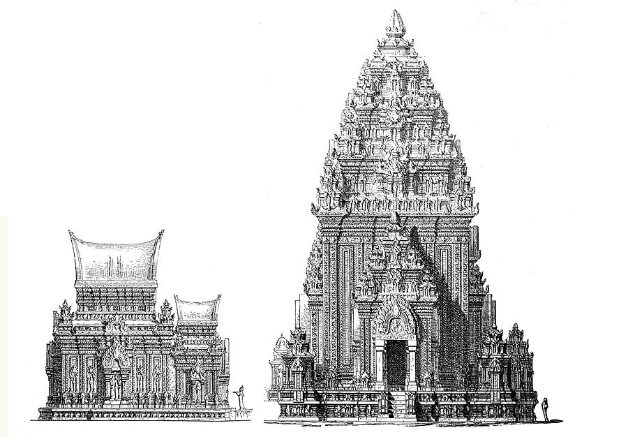
Figure 34. My Son Sanctuary Temples C1 (left) and A1 (right), Vietnam. 1904 survey drawings by archaeologist, Henri Parmentier, French École française d'Extrême-Orient (Parmentier 1909).
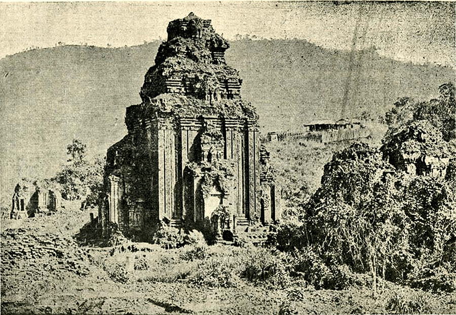
Figure 35. My Son Sanctuary, Temple A1 ruin, Vietnam, as found abandoned in the jungle by the French expedition. 1904 photograph by artist Charles Carpeaux, École française d'Extrême-Orient. At the time of the French survey, the ruins of 70 temples existed; of these, only 25 remain today—a result of extensive U.S. carpet bombing during the war.
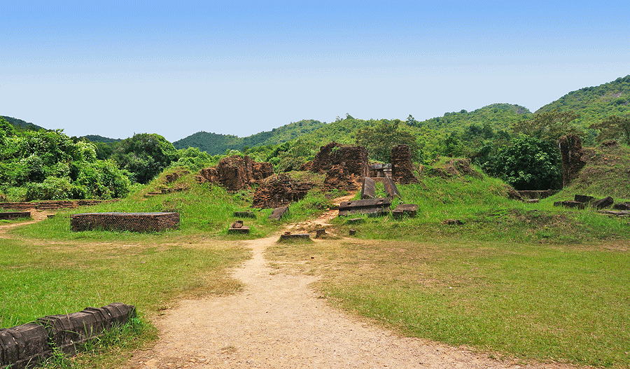
Figure 36. My Son Sanctuary, Temple A1, bombed-out ruins, 2014 photograph by author. The Sanctuary was also peppered with land mines from the war, which resulted in the deaths of several archaeological investigators during recent excavations.
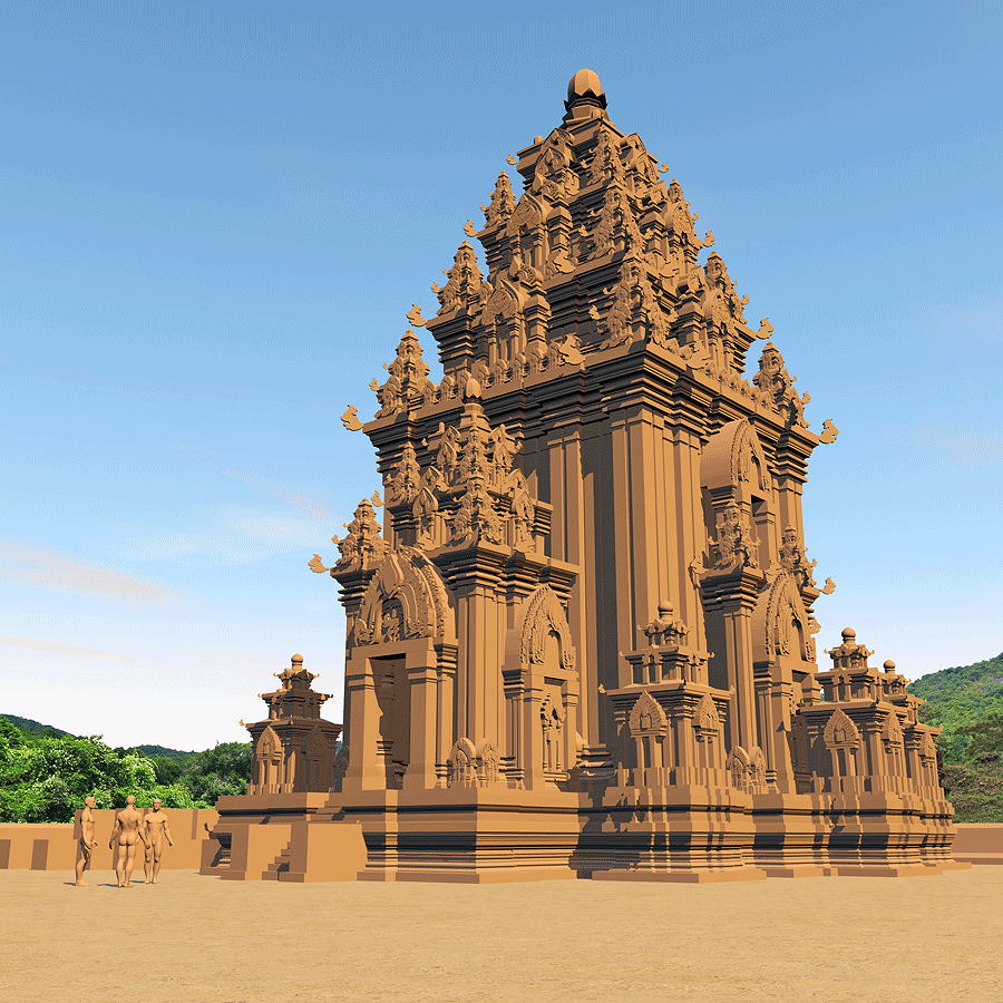
Figure 37. My Son Sanctuary Temple A1, upriver from the Champa port of Hoi An, Vietnam. View of the VR reconstruction model based upon 1904 survey by archaeologist Henri Parmentier, French École française d'Extrême-Orient with 3-D Temple model image in photomontage onto actual site photo. The method of fi ring of the massive brick structure continues to be a subject of controversy among archaeologists and architects, with one hypothesis positing that the entire structure was built of raw brick, sculpted, and then fi red in situ (Trà Thanh, 2015). This study was the author's introduction to the vast subject of the architecture of the Austronesian language group, which spans the largest area of Earth, from Southeast Asia to Australia and from Madagascar to the Hawaiian Islands. __________________________________________________________________________________________________________________ References Andrews, George Angelopoulos, Anthanasios G., Anthony F. Aveni, editor Barnhart, Edwin L. Castillo, Santiago Uceda Conklin, William J., and Jeffrey Quilter, editors Di Peso, Charles Hemming, John., and Edward Ranney Jochelson, Waldemar Jett, Stephen C., and Virginia E. Spencer Kidder, Alfred V. Kuckelman, Kristin A., editor Lau, George F. Lekson, Stephen H. Markus, Joyce, and Kent V. Flannery Marshall, Michael P. Mehdipour, Armin, and Ali Namazian Morgan, William N. Nabokov, Peter Parmentier, Henri Roberts, Frank H.H. Rohn, Arthur H. Ruskin, John Schmidt, Klaus Trà Thanh Toàn |